

The National Weather Service has issued a Winter Storm Warning for the entire Washington region from 11 p.m. Saturday through 4 a.m. Monday, but not all portions of this storm will hit equally hard across all neighborhoods. Understanding the specific timing of the heaviest snow and most dangerous ice can help residents make critical decisions about travel, power preparedness, and safety.
Here’s a breakdown of when conditions will be most dangerous in different parts of the region:
1. The Deceptive Beginning: Saturday 9-11 p.m.
Light snow is expected to arrive between 9 p.m. and 11 p.m. Saturday, starting first in southwestern counties and moving northeast. While accumulations will be minimal during these hours (likely just a trace to 1 inch) this is the last window for any final preparations. Roads will still be passable, but that window closes quickly after midnight.
2. Peak Snowfall Intensity: Sunday 12-6 a.m.
The storm reaches peak intensity overnight Saturday into Sunday morning across the entire region. The National Weather Service warns that snow could fall at rates of 1 to 2 inches per hour during this period.
“Snow will likely overspread the area Saturday night, becoming heavy at times with rates of one to two inches per hour possible at times,” according to the Winter Storm Warning issued Friday morning.
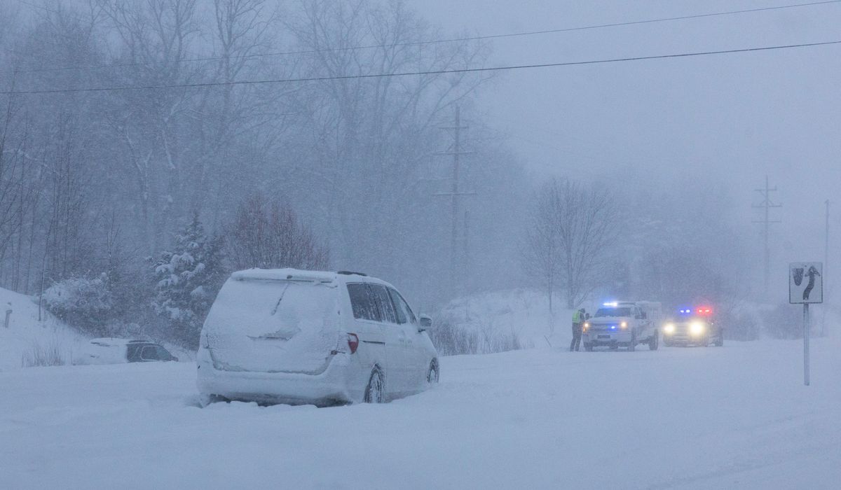
By sunrise Sunday, several inches of snow are expected across much of the region. This is when travelers face the greatest danger from rapidly deteriorating visibility and accumulating snow on roadways.
3. The Geographic Split Begins: Sunday 9 a.m.-12 p.m.
This is when the storm’s impacts begin to vary dramatically by neighborhood. Areas north and west of I-95, including Frederick, Gaithersburg, Leesburg, and Purcellville, will continue to see pure, heavy snow with an additional 2 to 6 inches during this three-hour window.
Southeast of Washington, including areas like Waldorf, College Park, and Bowie, snow will begin mixing with sleet during late morning. While this mixing reduces total snow accumulation, it creates dangerous road conditions as sleet bounces and accumulates on already snow-covered surfaces.
4. Ice Threat Escalates: Sunday 1-4 p.m.
Sunday afternoon marks the most dangerous phase for areas along and east of I-95, including downtown Washington, Alexandria, Fairfax, and College Park. Sleet will be falling across these areas, with the possibility of freezing rain developing.
“A mix with sleet or freezing rain is expected Sunday. Significant icing is possible especially south of Highway 50,” the Weather Service warned.
Areas south of Route 50, including Southern Maryland communities and parts of Northern Virginia, face the highest risk of significant ice accumulation during these hours. Ice accumulations of one to two tenths of an inch are forecast, enough to bring down tree limbs and power lines.
5. The Power Outage Window: Sunday 6 p.m.-Monday 2 a.m.
While precipitation intensity decreases during the evening hours Sunday, this period poses the greatest threat for widespread power outages. Trees and power lines will have accumulated maximum ice and snow weight, and any wind gusts can cause failures.
The storm’s wintry mix is expected to taper off late Sunday night into the pre-dawn hours Monday, but the damage to infrastructure may already be done by this point.
Northwestern suburbs including Frederick, Hagerstown, and areas near the Pennsylvania line will continue seeing heavy snow during the early evening, with an additional 2 to 4 inches possible before the storm finally winds down.
6. The Treacherous Commute: Monday 4-10 a.m.
While the heaviest precipitation should end by 4 a.m. Monday, the National Weather Service warns that “the hazardous conditions could impact the Monday morning commute.” Temperatures will remain well below freezing, likely in the mid-20s, meaning nothing will melt and refreezing of any slush is likely.
Mayor Muriel Bowser declared a Snow Emergency effective at noon Saturday through 9:30 a.m. Tuesday, acknowledging that the storm’s impacts will extend well beyond when the last snowflake falls.
7. The Deep Freeze: Monday 10 a.m.-Wednesday Afternoon
Temperatures will remain below freezing through at least Wednesday afternoon, with overnight wind chill lows expected to dip below zero. This prolonged cold means slower snow and ice cleanup, continued dangerous road conditions, and increased risk of water main troubles and cold-related illness.
“A prolonged period wind chills in the teens and single digits is likely beginning this evening and lasting through the middle of next week, with sub-zero wind chills possible at times,” the Weather Service stated.
8. Snow Emergency Deadline: Saturday Noon
While not a weather window, this is a critical deadline for residents: all vehicles must be moved off snow emergency routes by noon Saturday or face ticketing and towing. The towed vehicle locator office can be reached at 202-541-6083.
Next week
And of course, there will continue to be the potential for dangerous hazards throughout the week. Remember, even after precipitation ends, ice-laden tree branches and power lines can continue falling for days, especially during any wind gusts or as temperatures fluctuate. This delayed hazard means residents should remain cautious even after skies clear.
With near-record or record-breaking cold temperatures expected through early next week, the NWS Weather Prediction Center warns that peak power demand could exceed 130,000 megawatts for seven consecutive days beginning Tuesday. It’s a concerning scenario that the nation’s largest power grid operator PJM Interconnected has never experienced. Simply put, think ahead and prepare an emergency plan should you lose power or need help.
This article is written with the assistance of generative artificial intelligence based solely on Washington Times original reporting and wire services. For more information, please read our AI policy or contact Steve Fink, Director of Artificial Intelligence, at sfink@washingtontimes.com
The Washington Times AI Ethics Newsroom Committee can be reached at aispotlight@washingtontimes.com.